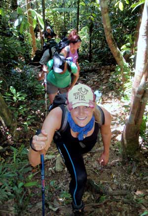

The Atherton Tablelands region is home to the highest peaks in Queensland, sparkling crater lakes, World Heritage listed rainforest and is interspersed with numerous walking trails. Some are short and suited to the inexperienced walker while others provide challenging and lengthy treks.
Take a walk (about 3 kms) around the village of Yungaburra using the ‘Old Town Loop’ as your guide – view Yungaburra Old Town Loop map. Or walk along the “Peterson Creek Track” also within the village (2km each way) – to possibly see Platypus and Tree-Kangaroos. Maps available at the Information Centre in Yungaburra.
Not far from the village are the renowned crater lakes of Lake Eacham and Lake Barrine both with walking tracks around their circumferences (3kms & 5kms respectively). Or penetrate deep into the wilderness of the rainforest and rugged ranges. Treks can be arranged with local guides. The options are endless.
“Tropical Walking Tracks of North Qld.” – authored by Kym Dungey and Jane Whitlaw – Footloose Publications 2007, offers comprehensive advice for walkers of all abilities and covers most walks in the region extending from Cooktown to Townsville including the Tablelands.
Tableland Adventure Guides offers information on walking conditions and more. Call Peter on 0441 851 7979 or go to www.tablelandadventureguides.com.au.
The Tableland Bushwalking Club offer interesting walks on Wednesdays and Sundays fortnightly. Visit them on www.tablelandsbushwalking.org/.
Popular Walks and Hikes On and Around the Tablelands
Crater Lakes National Parks via Yungaburra offers short, ‘any season’ walks around Lake Eacham and Barrine with excellent wildlife viewing opportunities. Go to www.nprsr.qld.gov.au/parks/crater-lakes/index.html for full details.
Mount Baldy and Widow Maker circuit – both easily accessible from Atherton, offer short but steep walks – go to www.nprsr.qld.gov.au/parks/herberton-range/about.html#Walking for more information.
There are a range of excellent ‘dry country’ walks starting at the Herberton Information Centre which cater for all levels of fitness. Visit www.herbertonvisitorcentre.com.au/walks.htm to get a sense of what is on offer.
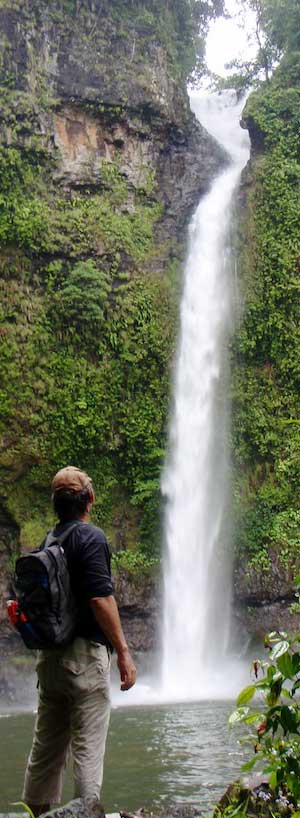
Wooroonooran National Park – accessible from numerous points on the Atherton Tablelands, offers a number of hiking options – particularly in the dry season May through to November. Explore the ‘Misty Mountains’ for a day or longer or enjoy a leisurely stroll through verdant rainforest to one of the beautiful waterfall off the Palmerston Highway – see www.nprsr.qld.gov.au/parks/wooroonooran-palmerston/about.html#things_to_do.
More energetic hikers may consider the Goldfield Trail along the Mulgrave River – www.nprsr.qld.gov.au/parks/wooroonooran-goldfield/about.html or the iconic Mt. Bartle Frere – Queensland’s highest mountain. Visit www.nprsr.qld.gov.au/parks/bartle-frere/ for specific information and guidance on this challenging hike.
Danbulla National Park – accessible from Lake Tinaroo offers super short walks – see www.nprsr.qld.gov.au/parks/danbulla/ and the ‘drier’ Dinden/Davies Creek National Parks via Mareeba offer excellent walks and hikes throughout the year including the popular Kahlphalim Rock/Lambs Head circuit. For more info visit and www.nprsr.qld.gov.au/parks/davies-dinden-bare-hill/index.html.
Hiking Services
Equipment hire: Tableland Adventure Guides have hiking equipment for hire – call them on 0441 851 7979 or go to www.tablelandadventureguides.com.au.
Hiking Equipment: Atherton Gas and Camping have a good range of hiking and camping equipment. Talk to Bonnie, Roger or Mike on 40 912010 or visit their store on Mabel Street.
General Information: visit one of the region’s VIC’s for general information. The NPRSR – National Parks, Recreation, Sport and Racing website offers information of all the parks in the region and is also the portal for campsite bookings and permits – visit www.nprsr.qld.gov.au/parks/list.php?region=60&facility=82.
Guided tours: Tableland Adventure Guides offer a range of guided hiking and trekking tours from ½ day to 4 days – call them on 0441 851 7979 or go to www.tablelandadventureguides.com.au.
Lake Tinaroo – Danbulla Forest Drive
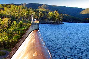
Starting at Tinaroo Township, drive to the Tinaroo dam wall to view the current level of the lake. Continue along Tinaroo Falls Dam Road to encircle the lake. This road is not suitable for caravans and ensure that you check the road conditions in advance. Danbulla State Forest has six camping areas – Bookings and several bushwalking tracks. The forest drive exits on Boar Pocket Road to the Gillies Highway.
Atherton Forest Mountain Bike Park
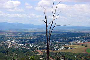
Get on your bike to adventure on a network of Herberton Range trails. Choose the trail to suit your fitness level – Atherton Forest Mountain Bike Park Map.
Ride under a canopy of shady Eucalypt trees and enjoy expansive views. Watch out for the wildlife! More
– 20 minute drive from Yungaburra