Yungaburra takes its name from the Dulgubarra Yidinji language. Though Yungaburra was always a place of meeting of
the Ngadjon-Jii and the Dulgubarra Yidinji tribes, the township is named after the Queensland Silver Ash tree, Janggaburru (pronounced Jungabooru). ****
The European settlement of Yungaburra spans from the early 1880s, but the history goes back much further.
Historic Walking Map of Yungaburra
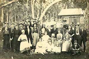
Yungaburra village has existed largely unchanged since 1910. Many of the buildings in the heart of the village remain in their original splendor. Yungaburra has the highest proportion of heritage listed buildings outside of regional centres in Queensland. This walking map of the old town loop takes in many of these buildings. Download and printout the Historic Yungaburra Brochure and Old Town Loop map. There are many excellent books researched and published by the Eacham Historical Society that detail the history of Yungaburra and the Atherton Tablelands, and give insight into the lives of the pioneers who settled here.
A Volcanic Start
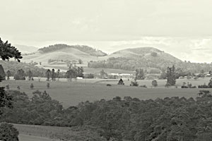 The geological history of the area stretches back many years ago, when the Atherton Tableland was a deep ocean basin. The region changed with sediments squeezed upwards forming high mountain ranges. About 260 million years ago violent eruptions and magma caused further changes in the landscape.
About 7 million years ago, vast amount of lava flowed form a number of shield volcanoes, spreading over the landscape and cooling to form a dense layer of basalt. Volcanic activity has been intermittent on the tableland for the past 3 million years, with the most recent eruptions being perhaps as recent as 10,000 years ago or so.
Geological Features near Yungaburra:
Seven Sisters and Mt Quincan
Volcanic cones created by explosive eruptions. As air vents opened, volcanic ash and scoria (light weight volcanic rocks with gas bubbles) hurled into the air, falling to build up cones around them.
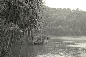 Lakes Eacham and Barrine
Explosive craters known as maars are created when rising lava came in contact with the water basin. The resulting steam cause a violent explosion , producing a crater. The craters have filled with rainwater. Where the water is able to drain off, a swamp rather than a lake forms. (Bromfield Swamp). The craters of Eacham and Barrine are thought to have been formed as recently as 10,000 years ago.
Mt Hypipamee Crater
Known as a diatreme, this crater is thought to have been created by a massive gas explosion, causing a deep cylindrical pipe through the granite approximately 142m deep.
First Inhabitants
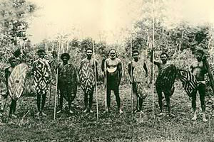 Before non-indigenous settlement, the Wet Tropics rainforests were populated with approximately 16 different tribal groups of Aboriginal people. They were small in stature with slender limbs. The forests were able to provide a rich diet of plants, nuts and fruit, supplemented with eels, wallabies, tree-kangaroos, possums, fish, birds and turkey eggs. Some unique cultural elements that reflect features of the rainforest habitat are dome-shaped, rain proof thatched huts that were used as semi-permanent wet- season camps.
As the settlements increased, the rainforest people were forced to retreat to the inaccessible areas they lost the use of their full range of habitats. Tribes were probably reduced to less than 20% of their pre-contact numbers within 20 years from European diseases and conflicts with settlers.
For a more detailed look at the Ngadjonji Tribe who traditionally occupied an area of upland rainforest country at the headwaters of the Russell and North Johnstone Rivers in north east Queensland, view Ngadjonji History of the Rainforest People.
A Short History of Yungaburra
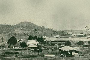 Yungaburra was originally called site Pocket. The district was developed in the early 1880′s as an overnight stop for miners and settlers who came from the coast on their way to the tin and gold fields farther west. Shanties grew up along the pack tracks at Boar Pocket (near Lake Barrine) and Ball Pocket (later the township of Kulara which was flooded with the construction of Tinaroo Dam).
In 1886 the land around site Pocket and Lake Eacham was surveyed for settlement. In 1891 the settlers moved in. The 40 acre blocks were a mixture of scrub and open forest. Those who selected jungle-covered blocks had to clear them by felling the trees and then burning off. Homes were built of timber slabs, with roofs of bark or wooden shingles; beds were sackbag stretchers and cooking was done over open fires. The highest priority was to provide food. Maize, pumpkins, sweet potatoes and other vegetables flourished in the newly cultivated soil but crops had to be protected from wildlife.
 A pioneer saying was ” the soil was so good that when you planted corn it would come up overnight – it did too, for the bandicoots would bring it up”.
Eventually grass was sown and a few cows introduced to provide milk, butter and beef. Often it was the women and children who remained alone on their blocks of land while the men took casual employment elsewhere to provide money for basic necessities of living.
**** Information from Elder Laurie Padmore
Dulgubarra